Spitzkoppe after good rains
The Erongo Region covers an area of 63,586 km2, which comprises 7.7 per cent of Namibia’s total area of about 823,680 km2.
The political regions of Kunene (to its north), Otjozondjupa (northeast), Khomas (southeast) and Hardap (south) surround the Erongo Region.
The Erongo Region stretches from the Central Plateau westwards across the Central-Western Plains and Escarpment to the Central Namibian coast, roughly over a distance between 200 and 350 km. Northwards the stretches from the Ugab River in the north to the Kuiseb River in the south over a distance of up to 300 km. On the west it is flanked by the Atlantic Ocean.
The Central-Western Plains were largely formed by erosion cutting eastwards into the higher ground, thereby forming the catchment area of several major ephemeral rivers such a the Khan, Omaruru, Swakop and Ugab, which waters would all reach the sea when in full flood during a good rainy season.

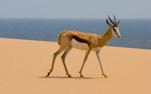
Springbok-with-the-sea-in-the-background-Sandwich-Harbour-4×4
On its southern border the Kuiseb River, distinctively divides the large sea of dunes to the south and gravel plains to the north. Interestingly, this river does not reach the sea when in flood but the water disappears into the sand at the Kuiseb Delta, from which Walvis Bay extracts underground water supplies
The Brandberg, with its tallest peak Königstein at 2,606 m above sea level, is Namibia’s highest mountain It is composed of a single mass of granite that rose through the earth’s crust some 120 million years ago. The Brandberg has one of the richest selections of rock paintings, including the world-famous ‘White Lady’. The Damara/Nama name for the mountain is Dâures, which means ‘burning mountain’, and Otjiherero name, ‘Omukuruvaro’ means ‘mountain of the Gods’.
Just southwest of this mountain is the Messum crater, a flat basin, with a diameter of up to 18 km. Consisting of barren reddish basalt rock, it is the remnant of a huge subterranean volcanic chamber from the time when Africa and South America split during the break-up of Gondwanaland.
One of the most distinctive landmarks is the Spitzkoppe, an imposing granite rock formation of which the summit is 1,728 m above sea level, situated about 50 km from Usakos, and clearly visible from the main road leading to Swakopmund.
The Region was named after the Erongo Mountain range, of which the western peaks rise 2,302 m above sea level. The mountain is an eroded relic of a volcano that was active some 140 – 150 million years ago. It dominates the flat plains west of Omaruru is flanked by the Namib Desert to the west and a mixed, woodland savannah to the east.

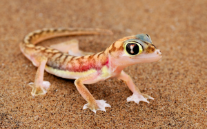
Palmato-Gecko-NACOMA
The Namib Desert covers the whole Namibian coastline of 1,570 km. It is 55-80 million years old and considered to be the oldest desert in the world. Namib in Damara/Nama means ‘vast place’.
The desert geology consists of sand seas near the coast, while gravel plains and scattered mountain outcrops occur further inland. Here some of the highest sand dunes can be found, of which some are 300 m high.
The hyper-arid Namibian coastal ecosystem is home to a significant and unique array of biological and ecological diversity, including uniquely adapted plants and animals, rich estuarine fauna and a high diversity of migratory shore and seabirds. Namibia’s coastal zones are considered as refuge for a number of endangered species.
The waters of the Namibian coast, with its icy and nutrient-rich Benguela current, support some of the greatest concentrations of marine life found anywhere in the world. It is one of the world’s most productive marine environments, not only in terms of fishery resources but also mineral deposits.